Applied Water Science ( IF 5.5 ) Pub Date : 2024-05-11 , DOI: 10.1007/s13201-024-02190-7 Yacine Abdelbaset Berrezel , Chérifa Abdelbaki , Bouchrit Rouissat , Tarik Boumaaza , Mohamed Saber , Matheus Goosen , Navneet Kumar
|
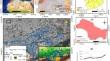
Water resource management relies heavily on the utilization of decision-making systems to guide the strategic rehabilitation and renovation of infrastructure within water distribution networks (WDNs). This study aims to develop and apply a scripting tool in ArcGIS for decision-making in WDN. It combines a collection of decision support systems, including Geographic Information Systems (GIS) and multi-criteria analysis, for infrastructure renovation and rehabilitation. The research is divided into two main sections. The first focuses on creating and implementing the analytic hierarchy process tool in ArcGIS, while the second discusses its application in the study area, which is the drinking water distribution network of an urban area in Tlemcen, located in the Northwest of Algeria. The study’s results reveal that 25% of the network is in critical condition and require immediate rehabilitation. Sixty-two percentage of the network is classified as moderately urgent, indicating a pressing but less immediate need for intervention. Finally, the remaining 13% of the network requires attention over a longer timeframe for rehabilitation. The main criteria influencing pipe prioritization are material (26% of total weight), laying date (26% of total weight), and pressure (20% of total weight). This developed tool can be easily adapted and applied by engineers and water management officers. It serves as a guide for decision-makers and planners in urban water management in Tlemcen and can be replicated and applied to other areas worldwide.
中文翻译:
基于 GIS 的自动化决策工具,用于修复阿尔及利亚特莱姆森的饮用水基础设施
水资源管理在很大程度上依赖于决策系统的利用来指导配水网络(WDN)内基础设施的战略修复和改造。本研究旨在开发并应用 ArcGIS 脚本工具来进行 WDN 决策。它结合了一系列决策支持系统,包括地理信息系统 (GIS) 和多标准分析,用于基础设施改造和修复。该研究分为两个主要部分。第一个重点是在 ArcGIS 中创建和实现层次分析处理工具,第二个讨论其在研究区域中的应用,该研究区域是位于阿尔及利亚西北部的特莱姆森市区的饮用水分配网络。研究结果显示,25% 的网络处于危急状态,需要立即修复。 62% 的网络被归类为中等紧急,表明迫切但不太迫切需要干预。最后,网络中剩余的 13% 需要在较长时间内得到关注以进行修复。影响管道优先级的主要标准是材料(总重量的 26%)、铺设日期(总重量的 26%)和压力(总重量的 20%)。工程师和水管理官员可以轻松调整和应用这一开发的工具。它可以作为特莱姆森城市水管理决策者和规划者的指南,并且可以复制和应用到世界其他地区。


 京公网安备 11010802027423号