


Introduction
Stratigraphic laws, principles (Harris Reference Harris1989) and associated data form the backbone of excavation records at archaeological sites. These data underpin the integrated analysis and wider interpretation of sites, as well as forming much of the growing accessible digital archive of data and reports generated through the commercial archaeological sector in the UK and internationally. The stratigraphic record then, especially for stratigraphically complex sites, is the key mechanism through which excavation records may be revisited, the relevance and reusability of data may be assessed and the underlying details that led to interpretations may again be pieced together.
The records for most sites with any stratigraphic complexity are typically visualised and analysed using a stratigraphic matrix diagram. This diagram serves as vital evidence for the excavation sequence and approach. Yet, if these records are retained only as paper or scanned diagrams, the easy reuse and reinterpretation of stratigraphic data and associated records are hindered. Key phasing data and indices, which are fundamental for understanding interpretations of sites and integral to published narratives, are not consistently digitally archived and it remains difficult to ascertain how much primary or secondary stratigraphic data are actually reused. Even where such data are digitised and archived, repositories such as the Archaeology Data Service (based at the University of York) measure downloads of files but do not track how those files are (re)used. Furthermore, the Archaeology Data Service currently holds only 2–3 per cent of all the commercial archaeological data produced in the UK (Tsang Reference Tsang2021). Our findings indicate that digital stratigraphic records remain largely unsearchable and unconnected, essentially un-‘FAIR’—an acronym coined by Wilkinson et al. (Reference Wilkinson, Dumontier and Albersberg2016), which stands for ‘findable, accessible, interoperable and reusable’. These principles are intended to guide data management and stewardship practices towards enhancing the utility and longevity of data assets (for a detailed discussion on the application and importance of these principles within our context, refer to May et al. Reference May, Taylor and Binding2023, section 1.2).
It is not clear from our investigations the degree to which stratigraphic data are currently reused, given the seeming lack of evidence for it in the openly accessible digital archives of commercial archaeological work. Nevertheless, we argue that consistent archiving of these data is crucial for several reasons. Stratigraphic data not only underpin archaeological narratives, they are also foundational in shaping our understanding of historical contexts and can be re-examined to understand, validate or even re-evaluate prior interpretations.
Apart from showing transparency of method and interpretation, this re-evaluation is critical when excavations occur at different times in adjacent areas or during large infrastructure projects. Stratigraphic data also aid in, and are often reused for, deposit modelling, offering a comprehensive view of an area's history and guiding strategic environmental assessments. Primary stratigraphic data are furthermore indispensable for tasks such as Bayesian chronological modelling of dating evidence, which is currently revolutionising archaeological dating (see for example, Whittle & Bayliss Reference Whittle and Bayliss2007; Marciniak et al. Reference Marciniak, Barański, Bayliss, Czerniak, Goslar, Southon and Taylor2015; and Figure 1). For this type of modelling, access to standard stratigraphic outputs—such as matrices, phasing, grouping information and land-use diagrams—is paramount. The absence of standardised digital archiving practices and inconsistencies in data deposition limit the reuse potential of archaeological data. Thus, emphasising best practices for stratigraphic data deposition and reuse can substantially improve research outcomes, accuracy and interoperability within archaeology.

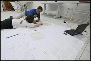
Figure 1. Archaeological stratigraphers, analysing a Harris matrix for the purpose of conducting Bayesian Chronological Analysis (photograph by Jason Quinlan, courtesy of the Çatalhöyük Research Project).
In this article, we consider the way evolving digital practice is shaping post-excavation processes that rely on stratigraphic data and consider whether there is a need to rethink the way we approach the ‘dark arts’ of post-excavation work to improve best practice for stratigraphic archiving. We present a prototype tool called ‘Phaser’ that is designed to help create, import, analyse and better manage stratigraphic data, while also facilitating greater consistency and interoperability in the data that it outputs, thereby maximising the reuse potential.
Current approaches to stratigraphic analysis
Compared to the plethora of organisational and project-specific field manuals and academic publications related specifically to the methodology and practice of field recording (for a far-from exhaustive list, see the online supplementary material), there is a relative dearth of literature pertaining to the techniques, method and practice of post-excavation analysis of fieldwork (and specifically excavation) data. Notable exceptions include Frederika Hammer's (no longer live) web-based Post-Ex. Manual (Hammer Reference Hammer2002) and Roskams’ (Reference Roskams2001) seminal volume Excavation (see also, for example, Westman & Shepherd Reference Westman and Shepherd1992; Pearson & Williams Reference Pearson, Williams, Harris, Brown III and Brown1993; Carver Reference Carver2009; Davies Reference Davies2015, Reference Davies2017; Lavan & Mulryan Reference Lavan and Mulryan2016), as well as occasional unpublished in-house commercial guidelines such as those by Headland Archaeology and Museum of London Archaeology (see May et al. Reference May, Taylor and Binding2023, section 3.3). Otherwise, since the demise of the Interpreting stratigraphy conference series of the 1990s (Roskams Reference Roskams2000), discussion of post-excavation techniques is typically relegated to generalised discourse in relevant chapters of undergraduate textbooks (e.g. Renfrew & Bahn Reference Renfrew and Bahn2005; Gamble Reference Gamble2008), or focused on highly specific aspects of analysis (such as dealing with material culture or sample processing and analysis), with the ‘nuts and bolts’ of ‘how to do’ stratigraphy (both in terms of construction of the Harris matrix and its subsequent analysis; Figure 1) often sorely neglected.
Chadwick (Reference Chadwick1997: 3) suggests that the Harris matrix diagram “forms the basis of stratigraphic recording and presentation in most British excavation methodology”. This remains a truism, certainly for most sites, but it is important to acknowledge that for dispersed rural sites, or sites with very minimal stratigraphic relationships, the amount of work involved in compiling a detailed site-wide matrix might outweigh its usefulness. Accepting this caveat, it is still useful when considering how stratigraphy is analysed (from a UK perspective at least), to take Harris (Reference Harris1989) as a starting point. Harris set out a process (Figure 2) of defining the ‘stratigraphic unit’ in the field and compiling a record to support this definition which documents the stratigraphic relationships so that a matrix can be constructed. That matrix can then be grouped by phase and period in order to support the finds analysis and report writing. In this sense, Harris’ approach can be broadly divided into two sets of activities: 1) primary stratigraphic observation and recording taking place in the present; and 2) secondary stratigraphic analysis and interpretation of hypothesised past events. These activities can implicitly be seen to take place on- and off-site respectively and, in Harris’ approach, both serve a supporting role in finds analysis and site-narrative construction.

Figure 2. Diagram synthesising the process of constructing a Harris matrix, as envisioned by Harris (Reference Harris1989) (figure by authors).
This model of on-site observation and off-site analysis is reflected in every subsequent treatise on stratigraphic analysis. Pearson and Williams (Reference Pearson, Williams, Harris, Brown III and Brown1993), for example, make an explicit distinction between the recording phase (i.e. collation of stratigraphic observations and evidencing of stratigraphic relationships) and analysis of the stratigraphy, which is seen as a post-excavation activity despite a clear advocation for commencing the construction of the Harris matrix on site (Pearson & Williams Reference Pearson, Williams, Harris, Brown III and Brown1993: 93). Similarly, the workflow outlined by Hammer (Reference Hammer2002) in her post-excavation manual, maintains this distinction between (debatably) objective collection of ‘raw’ stratigraphic data during the excavation phase of a project, and the (arguably) more interpretative process of analysis of these data to generate information about the site spatiofunctionally (by grouping stratigraphic units) or spatiotemporally (by phasing stratigraphic units). These approaches to stratigraphic analysis are echoed in Roskams’ (Reference Roskams2001) seminal book, where he details the post-excavation analytical process (see Figure 3).

Figure 3. Diagram showing the process of post-excavation stratigraphic analysis as set out by Roskams (Reference Roskams2001: 241) (figure by authors).
The process of stratigraphic analysis (Figure 4) has remained largely unchanged, despite a recent shift towards the greater utilisation of digital tools (see below) and the varying pace at which different organisations adopt these digital techniques; some focus predominantly on digitisation of records and others increasingly generate ‘born digital’ data (i.e data that originates in a digital format, as opposed to being converted from analogue records, such as site records created directly on digital devices during excavation). Regardless of how the data are generated or recorded, it remains essential to effectively document the stratigraphy. In practice the distinction between when certain ‘analytical’ activities happen is more blurred than the workflows in our diagram indicate. In line with Hodder's thinking on the nature of the interpretive process “at the trowel's edge” (Hodder Reference Hodder1997: 694), excavators often keep running matrices from the moment they commence excavating a site. These matrices are used on site to contemporise sequences, spatiofunctional groupings, ‘nodal’ deposits or truncations, and even phasing while excavation and recording are ongoing, further evidencing the false dichotomy between objective recording and subjective interpretative analysis.

Figure 4. Typical archaeological stratigraphic workflow with associated outputs (figure by authors).
As a means of visualising primary observations/interpretations that underpin all subsequent narratives and understanding of a site, the Harris matrix can be considered a form of raw stratigraphic data vital for determining phasing (and grouping) as a mode of interpretative analysis. Construction of the Harris matrix is an intrinsic step in our knowledge creation process and therefore (we would argue) when used it should be seen as part of the primary archive of any complex excavation, if only in the interest of practising good transparent science (i.e. showing your working out).
Computing and stratigraphy
At its heart the Harris matrix is a model; a visual graph diagram (Dye & Buck Reference Dye and Buck2015) constructed using a fairly straightforward system of logic (see below). As such it lends itself well to computational approaches to automating its layout and, accordingly, a tradition of computational solutions to handling and visualising raw archaeological stratigraphic data has emerged (see May et al. Reference May, Taylor and Binding2023, section 6.1). Most of these software solutions are, however, no longer supported or highly proprietary and there is no industry standard. Moreover, most of this software does not fulfil the needs of archaeologists to check, validate and really understand the dating of their sequences to enable full chronological analysis. So, unsurprisingly, many archaeologists still resort to hand-drawing their matrix and many others simulate this process by using more generic ‘off-the-shelf’ software (i.e. spreadsheets and computer-aided design). Fundamentally then, all these computational approaches to stratigraphic analysis have not really changed the way we ‘do’ stratigraphic analysis. The process is essentially still about validating stratigraphic relationships and correlations by overlaying (now digital) plans, and coding groups and phases into the spatial data. These techniques are in essence digital skeuomorphs (after Taylor & Dell'Unto Reference Taylor and Dell'Unto2021) and many of these digital Harris matrices can raise as many problems for archiving and reuse as their analogue counterparts.
A number of research projects in the past 20 years have attempted to draw together archaeological archives from different excavation teams to analyse temporal sequences and use stratigraphic relationships to cross-search for artefacts and structures from related phases excavated at different sites (e.g. the STAR project, see Tudhope et al. Reference Tudhope, Binding, Jeffrey, May and Vlachidis2011). For chronological modellers—key reusers of archaeological stratigraphic data—barriers to the archiving and reuse of stratigraphic data are also exacerbated by a lack of standardised approaches to the archiving of stratigraphic data, often held in hard-copy matrix diagrams or inconsistently structured database tables (Moody et al. Reference Moody, Dye, May, Wright and Buck2021).
Evolving practices and influences upon analysis
It is worth noting here that, as Carver points out:
It may be that due to a glitch in archaeological history, an isolated group of Britons are using the terms ‘context recording/Harris matrix’ as a nickname for stratigraphic excavation, something that has, of course, been around very much longer and is a great deal more versatile. But even stratigraphic excavation is not the only way of making history (Carver Reference Carver2011: 23).
While we concur that single context recording is only one way to dig stratigraphically (cf. for example Carvers’ Feature-Group or the Germano-Swiss school of ‘sectional’ excavation), the thing it and other ‘stratigraphic’ systems have in common is that they give primacy to understanding and controlling the stratigraphy in the primary recording. They can, therefore, be directly contrasted with traditions of ‘planum’ excavation and ‘lot and loci’ (common in the US school of excavation), which tend to put primacy on the location of the material culture; reconstructing the stratigraphy afterwards.
So, focusing upon stratigraphic approaches that engage with Harris, how then, have things changed since the publication of Principles of archaeological stratigraphy in 1979 and its revision in 1989 (Harris Reference Harris1989)? In some ways quite a lot and in others surprisingly little. This is because the ‘archaeological process’ we are trying to characterise and understand is, in practice, itself a ‘palimpsest’ of different layers of activities and influences that depend upon decisions and choices made throughout what is, most commonly but by no means exclusively, a project-centred approach to archaeological investigation. There is a multidimensional aspect to how different workflow processes are implemented in archaeological practice. This multidimensionality can be characterised as part of a wider ‘network’ of archaeological investigation activities, or, as Hodder might describe the even broader ‘archaeological process’, “[r]ather than a fixed network there may be an ever changing set of flows and interactions. This is what is meant by ‘the spatio-temporalization of archaeology’ ” (Hodder Reference Hodder1999: 180).
In the following sections we consider the influence of each of these different possible flows or ‘layers’ of process on archaeological practice. These ‘layers’ may be summarised—in rough order of their implementation, although in practice the way different organisations implement them is likely to be less linear and more organic—as:
1. Funding source and financial constraints (i.e. research or commercial);
2. Project management regime (research, commercial or infrastructure);
3. Location (urban or rural);
4. Scale (infrastructure or single site project), considering:
a. complexity/depth of stratigraphy of archaeology encountered, and
b. amount of dating evidence encountered in the stratigraphic units;
5. Methodological choices (single context versus multiple context, planum, locus, etc);
6. Staff resources and digital skills (required training and continuing professional development);
7. Digital practice and changes that will continue to develop (consider for example the impact of GIS, 3D technologies, Bayesian chronological modelling);
8. Research objectives (‘fashions’ of changing theory);
9. Data recorded in ‘the present’ (scientific statements and systematics; after Dunnell Reference Dunnell1971) as opposed to free-text interpretation about ‘the past’.
Archaeological project ‘layers’ and trajectories
Arguably the first consideration that determines how data are recorded and subsequently flow through ‘the process’ (Hodder Reference Hodder1999), is funding. Projects may be initiated before funding is in place, but it is hard to conceive of any projects that achieve much without adequate finance being secured when necessary. The point here is that funding streams determine the structure and deliverable outputs of a project. These are further influenced by local authority requirements (e.g. written schemes of investigation), which also guide the structure of commercial projects and can vary considerably in their detail and specificity. Funding and local authority requirements can also have a major impact on the dissemination of project outputs or products and whether data and archives are made publicly accessible at all, let alone FAIR or Open Access of the sort identified by the Open Data Institute (ODI) as: “Open data is data that anyone can access, use or share. Simple as that. When big companies or governments release non-personal data, it enables small businesses, citizens and medical researchers to develop resources which make crucial improvements to their communities” (ODI website https://theodi.org/news-and-events/blog/what-is-open-data/).
The need for an overall methodological approach in planning the nature and order of activities in archaeological projects is widely acknowledged. In the early 1990s, the guidance document Management of archaeological projects (second edition), or MAP2 for short, was published in the UK (English Heritage 1991). MAP2 promotes a systematic approach to the organisation of archaeological projects, from project initiation, through fieldwork, assessment and analysis, to publication and final archiving. In 2015, English Heritage (now Historic England) replaced the MAP2 guidance with Management of research projects for the historic environment (MoRPHE), which was intended to encompass archaeological projects along with other historic environment research activities. MoRPHE remains the current state guidance (Historic England 2015). Thus, project management regimes influence not just how data from an archaeological investigation are collected, be it stratigraphic or otherwise, but also what outputs from the project end up in the archive and how and when that process of archiving is undertaken.
The next ‘layer’, which most archaeologists will probably consider the most important, concerns the actual archaeology encountered on the site/project. As Carver summarises it:
There is an evaluation stage, which tells us how the archaeology survives in the ground, and a strategy stage which tells us what we have to do to see it. Since what we see depends on how hard we look, an archaeological investigation is not only determined by its objectives, but by its terrain (Carver Reference Carver2011: 29).
The project planning stages are important, but the details of what we end up doing, our choice of methodologies, how we conduct our analysis and what ends up in our stratigraphic records and archives is determined by what is actually in the ground, namely the ‘type’ of archaeology we encounter on the site we investigate and, as Carver emphasises, how ‘hard’ (well) we look for it (Carver Reference Carver2011).
As we have discussed elsewhere in more detail (May et al. Reference May, Taylor and Binding2023; section 5.2), more complex stratigraphic sequences are generally associated with the excavation of sites in ‘urban locations’ (Hammer Reference Hammer2002), where a greater number and depth of stratigraphic units are more likely to accumulate as a town or city develops. It is, however, worth noting here—particularly with regard to the discussion of funding sources and project management regimes—that certain large infrastructure projects, such as Heathrow Terminal 5 (Andrews et al. Reference Andrews, Barrett and Lewis2000), had significantly different, and at the time seemingly influential, methodologies and outputs. This might be partly because they took place on a ‘single’ large site, or project, rather than across a long swathe of liner construction involving different landscapes. But in the case of Terminal 5 it should be noted that the development funders, the British Airport Authority (BAA), demanded and imposed a particular project management regime that heavily influenced the archaeological methodology adopted for the infrastructure projects (BAA 1998). At the time, this was recognised and celebrated by the archaeologists involved:
BAA's requirement for efficient working practices and its commitment to invest in research and development to establish such practices has provided the opportunity to address some of the fundamental problems in the archaeological discipline (Andrews et al. Reference Andrews, Barrett and Lewis2000).
We have highlighted how the source and nature of project funding can strongly influence the methods employed and the outputs produced. The availability of staff who are able, willing or experienced enough to use stratigraphic analysis software is also closely related to project funding. Consultations with commercial archaeologists, conducted as part of the Arts and Humanities Research Council-funded project ‘The Matrix’ (May et al. Reference May, Taylor and Binding2023), highlighted the general absence of agreed policies for the availability and use of matrix analysis software, with Microsoft Excel often used as the default stand-in. The cost of software packages, such as Harris Matrix Composer, is often cited as a barrier to their wider use. Equally, the relative experience of some practitioners can lead to different outcomes—digitally literate practitioners might more easily transfer their skills and recent graduates may be more familiar with the software.
A general point about staff resources affecting outcomes is that staff availability can also influence outcomes. Staff availability can change over the course of a project, especially in commercially funded work. The person who directs or supervises the recording on site may not necessarily be the person that undertakes the stratigraphic analysis or that writes it up. This is highlighted by Davies:
Post-excavation projects therefore gradually changed as individual archaeological organisations developed their own internal processes and procedures … In practice this involved a move towards a more ad hoc form of post-excavation process (Davies Reference Davies2017: 179).
Use of the term ‘ad hoc’ here may be unfair; it is more likely that different organisations develop their own specific processes in the absence of a widely agreed approach to post-excavation documentation. Some of the more idiosyncratic variations in post-excavation practices could also derive from the lack of formal post-excavation training materials for archaeological practitioners and students, accounting for further inconsistencies in digital data outputs.
Changes to digital practice will continue to develop
An overview of the ‘archaeological process’ from excavation to the publication of the site report is illustrated in Figure 5, which has been adapted from Harris’ Principles of archaeological stratigraphy (1989: 139, fig. 57). This ‘bottom-up’ diagram roughly corresponds to the main project management stages (recording, analysis, publication, archive). Perhaps most notable here is the fact that Harris’ original diagram is of its time and therefore does not include a number of methods now in common usage, not least Geographic Information Systems (GIS), Bayesian chronological modelling and structure from motion recording. We have ‘layered’ these methods onto the original diagram, not to critique the original but rather to emphasise the point that new methods continue to be developed and introduced (again see Figure 5). The adoption of new technologies has already had a considerable effect on the outputs that emerge from the various stages, especially phase plan illustrations and the interpretation of the ‘stratigraphic sequence’ although, arguably, the effect on the stages of the process themselves has been less profound.

Figure 5. Diagram showing how stratigraphic data from an excavation go into the formation of the stratigraphic sequence (with new processes overlaid roughly by authors), which is then used for all later analyses of the artefacts and in the compilation of the site report (figure by authors; adapted from Harris Reference Harris1989: fig. 57).
The widespread use of Total Station Theodolite recording of stratigraphic unit boundaries and an uptick in the use of intrasite GIS in particular have greatly altered how individual context plans, and resulting phase plans, are produced and published. Yet there remain issues with the degree to which relational database management systems are able to handle temporality alongside spatial data, which presents challenges for the sophisticated modelling of spatiotemporality within GIS (see discussion in Taylor Reference Taylor2016). For this reason, matrix analysis software continues to find a role parallel to, or incorporated in, GIS in some software (cf. GSys and ASEbase).
Towards a best practice for archaeological stratigraphic analysis
As noted above, more than one method exists for undertaking archaeological stratigraphic analysis; the pursuit of a particular method depends on a range of factors that includes the nature of the project and the archaeology encountered. As archaeologists, our analytical tools and systems need to be flexible and adaptable, and yet digitally sustainable to facilitate the interoperability and reuse of our site and stratigraphic data. The lack of identifiable commonalities in archaeological recording and analysis practices manifests in post-excavation outputs. A variety of good practices are reflected in the different circumstances and methodologies outlined above and attempts to distil the best practice from all these different processes, as part of The Matrix project, led to the development of a prototype stratigraphic and chronological analysis tool, named Phaser. The most common practices were gathered as user requirements and embodied in the Phaser software tool, to assist archaeologists with incorporating best practice in their stratigraphic analysis and the production of corresponding digital archives.
Prototype stratigraphic analysis software—Phaser
The Phaser software enables archaeologists to input stratigraphic units and their relationships (or import them from archived .csv files), create and edit matrix diagrams and incorporate and analyse finds dating evidence along with scientific dates to build, analyse and export phased matrix diagrams and stratigraphic records in .csv and JSON (comma-separated value and JavaScript Object Notation) formats, for archive. Production of a full commercially supported stratigraphic analysis software package was not the aim of The Matrix project and the prototype software, designed by Ceri Binding, is an open-source, responsive, single page client-server application. This allows the application to be used via a web-browser on a variety of devices, with no additional installation or configuration required on the part of the user. The application and its associated documentation are hosted via GitHub (available at https://github.com/stratigraphic), which enables the ongoing availability of a documented working deployment of the prototype to persist beyond the official end date of the original project.
The matrix as a mechanism for recording versus the matrix as a tool for analysis
Along with embodying archaeological user requirements, the prototype also enabled investigation of the viability of using Allen Temporal Operators (Allen Reference Allen1983), demonstrating their ability to enhance the spatiotemporal and temporal reasoning and interpretation undertaken during stratigraphic analysis and incorporated in the Harris matrix diagram methodology (May Reference May2020; May et al. Reference May, Taylor and Binding2023).
Development of the prototype Phaser software, highlighted nuanced distinctions in approaches to matrix formation, highlighting the dual nature of the matrix in both practical and interpretive capacities:
1. Initially, during excavation, the matrix is formed from the top down, serving as a contemporaneous record. It meticulously documents the archaeologists’ interventions in the present, acting as a snapshot of ongoing processes.
2. The matrix evolves when we engage in stratigraphic analysis. Here, the focus shifts to building an understanding of the past. We reconstruct an archaeological sequence from the bottom up, infusing the matrix with hypothesised spatial groups and spatiotemporal phases. This iterative and reflective process transforms the matrix into a diagrammatic representation of historical interpretations.
These observations suggest that the matrix serves dual purposes. At the excavation site, it is a ‘primary record’ captured at the trowel's edge. Conversely, when we analyse stratigraphic relationships, incorporating dating and other secondary data, the matrix becomes a dynamic tool for visualisation and interpretation. This approach allows us to dissect and comprehend the complex web of stratigraphic (spatiotemporal) relationships.
Through this lens, the matrix is not merely a static entity but a dynamic interface between the present actions of the archaeologist and the interpreted narratives of the past. The dual roles of the matrix—as a primary record and as an interpretive illustration—are essential to both capture the reality of the excavation and to construct a narrative that brings the past to life.
Phaser and the terminology of stratigraphic records
The reuse of data is hindered by ambiguities of meaning in the terms used to label the data. One solution to this would be to develop an online manual as a repository for controlled terminology in the form of linked open data (LOD) that practitioners could use and reference to help dis-ambiguate the data within their records. The Phaser prototype tool uses Perio.do LOD period terminology, enabling users to reference—using an LOD persistent identifier—the most appropriate period terms for the spatiotemporal locality of the excavation from which their site data derive. Data from excavations conducted within the geopolitical boundaries of England, for example, are therefore referenced using period terms, along with their associated timeframes that are most applicable in England.
Equally useful would be a common ‘data package’ of stratigraphic data from excavation and analysis for submission to digital archaeological archives (including semantic interoperability of terminology such as group, phase, period). A number of controlled vocabulary ‘pick lists’ of terms in an online manual and any associated data package would help improve consistency and semantic interoperability by avoiding manual data entry through the use, or development of, a set of LOD-controlled terms. As Roskams pointed out over 20 years ago:
Turning next to data manipulation after excavation, there is a great need to sort out the concepts used in stratigraphic analysis […] to match the systematization which has been developed in the production of the site record (Roskams Reference Roskams2001: 278–79).
Conclusions and recommendations
A range of issues regarding how archaeologists record and interpret stratigraphic information affects the wider availability and reusability of these crucial data. A series of recommendations has been proposed to address some of the key issues (May et al. Reference May, Taylor and Binding2023). What is needed most is more consistency in the records that result from stratigraphic analysis and better research data management of existing archives (Higman et al. Reference Higman, Jones and Bangert2019). One way to achieve this would be through agreement upon the use of a common ‘data package’ of stratigraphic data from excavation and analysis for submission to digital archaeological archives (including semantic interoperability of terminology such as group, phase, period). Such a data package might include some form of phasing index (akin to the Index of Archaeological Association; Museum of London Archaeology 2019) along with the primary stratigraphic record from excavation. This approach should also be enshrined in the data management plans that are required either as part of ‘written scheme of investigation’ specifications in the development management process, or any fieldwork project undertaken with UK Research and Innovation or other national research funding.
The lack of standardised procedures within archaeological organisations for stratigraphic analysis, and many other post-excavation activities, is identified as a contributor to the lack of consistency in digital archaeological archives. Ultimately, the problems are bigger than can be addressed here and really need addressing in practice. To that end a project has been instigated (AH/X006735/1), with the support of the Federation of Archaeological Managers and Employers, to develop online resources for promoting FAIR and sustainable best practice within the commercial archaeological sector for the wider public benefit, in the UK and internationally. The aim is to build an online forum and community of practice for sharing best practice that will form the basis for editorial development of an online handbook of documentation on shared post-excavation practices and methodologies. The online resources could also be a potential resource for enhancing training and continued professional development across the sector. Such training materials could also be designed for knowledge exchange by university departments to incorporate in archaeological undergraduate and postgraduate teaching and field schools as well as local society groups.
These online resources will be piloted initially for stratigraphic analysis and related practices but, if the business model is appropriate, they could be developed for a wider set of related post-excavation analysis practices, including submission and format of specialist analysis data. This, in turn, would help improve the practices for sharing, interoperability and reuse (FAIRness) of data deposited in resulting archaeological archives. If a consensus can be achieved, the next step would be to investigate the viability and suitability of an international convention on archaeological stratigraphic and chronological methods and data.
Acknowledgements
The authors would like to thank Professor Doug Tudhope, Professor Caitlin Buck, Dr Tom Dye, Dr Holly Wright, Dr Edward Harris, Steve Roskams, Professor Tim Williams, Dr Alex Smith and Barney Sloane for their advice and critical insight, which helped to inform this project from the outset. Thanks are also due to Bryony Moody, whose complementary research and need for reusable stratigraphic data helped us to think through many of the issues we encountered over the course of the project.
Special thanks go to the team at Museum of London Archaeology: Louise Fowler, Dr Sara Perry, David Bowsher and all the XSM10 team, especially Al Telfer, Serena Ranieri and Rob Hartle, for so diligently archiving the outputs of their work in ways that enabled FAIR and Open play with their data.
Funding statement
This work was supported by the Arts and Humanities Research Council via funding under their grants (ref. AH/T002093/1), without which this research could not have taken place.
Supplementary material
To view supplementary material for this article, please visit https://doi.org/10.15184/aqy.2024.60.


 Open access