


Introduction
Investigation of sensory regimes can enrich the study of past human experiences. In recent decades, sensory research has gained ground in archaeology (Day & Skeates Reference Day and Skeates2020). Geographic Information System (GIS)-based modelling offers opportunities for measurement and replicability, surmounting some of the limitations of phenomenological approaches (Rennell Reference Rennell2012). Studies modelling viewsheds, viewnets and lines of sight are familiar to archaeologists (Gillings Reference Gillings, Wheatley, Gillings, Hacigüzeller and Lock2020) but, more recently, attention has turned to sound—the investigation of the acoustical properties of archaeological sites and attempts to reconstruct past soundscapes (Scarre & Lawson Reference Scarre and Lawson2006; Miller Reference Miller2008; S. Mills Reference Mills2014; Schofield Reference Schofield2014; Díaz-Andreu et al. Reference Díaz-Andreu, Atiénzar, Benito and Mattioli2017; Kolar et al. Reference Kolar, Covey and Cruzado Coronel2018; Primeau Reference Primeau2022).
In the Southwest USA, the study of sensory engagements goes hand in hand with understanding Indigenous worldviews and perceptions (Basso Reference Basso1996). In ancient Chaco Canyon, in north-west New Mexico, the sensory experience of place was bound up in politics, social relationships and community identity (Van Dyke Reference Van Dyke2007). Chacoan communities cluster around central, monumental buildings called great houses and, in this study, we use GIS-based modelling techniques to examine the soundscapes of five such communities. Archaeologists working in Chaco Canyon great houses have recovered trumpets made from conch shells obtained from the Pacific Ocean, 1000km to the south-west. These prized items would have provided their bearers, probably community leaders, with the means to create a very loud blast of sound. In a previous simulation involving two Chacoan communities (Van Dyke et al. Reference Van Dyke and Heitman2021), the modelled reach of the conch-shell blast mapped neatly onto community boundaries as defined by known habitation sites. In the current study, we replicate and expand this work at additional Chacoan communities, using similar soundshed modelling tools. We demonstrate that the modelled reach of a conch-shell blast from a Chacoan great house does consistently map onto the distribution of associated habitation sites. We then explore the possible reasons for this phenomenon, as well as its implications for Chacoan scholarship and the management of the archaeological landscape.
The Chacoan world
Chaco Canyon lies at the centre of the most complex sociopolitical phenomenon on the Colorado Plateau, in the heart of the San Juan Basin, in the ancient North American Southwest. The Colorado Plateau is home to Indigenous peoples whose ancestors have farmed this landscape for millennia. Between AD 850 and 1150, the canyon was the centre of the ancient Pueblo world. Twelve massive, sandstone masonry canyon great houses, including Pueblo Bonito, are some of the best-preserved pre-Hispanic buildings in the Southwest, with standing walls up to 8m high (Lekson Reference Lekson2006). Caches of unusual paraphernalia, including carved and painted birds and flowers, cylinder jars that held cacao, decorated baskets, and turquoise and shell jewellery indicate a rich body of religious practices and beliefs (Crown & Hurst Reference Crown and Hurst2009; Heitman & Plog Reference Heitman and Plog2015; Mattson Reference Mattson2016). These beliefs incorporated the celestial and terrestrial landscape, as indicated by astronomical alignments and rock art (Van Dyke & Heitman Reference Van Dyke and Heitman2021).
About 200 additional great houses dot the ‘greater Chaco landscape’ (GCL) beyond Chaco Canyon over an area covering approximately 60 000 square miles (Kantner & Mahoney Reference Kantner and Mahoney2000; Kantner & Kintigh Reference Kantner, Kintigh and Lekson2006; Van Dyke & Heitman Reference Van Dyke and Heitman2021). These great houses are usually central to a community of small, domestic habitation sites, and they are often accompanied by a highly structured landscape comprised of additional monumental constructions: great kivas, earthworks, road segments and enigmatic rock features (ERFs). ERFs include elements such as shrines, crescents, stone circles, basins, herraduras, zambullidas, atalayas and cairns (see descriptions in Van Dyke & Heitman Reference Van Dyke and Heitman2021: 135–79); they feature prominently in visibility studies (Van Dyke et al. Reference Van Dyke, Bocinsky, Windes and Robinson2016).
Opinions differ on the nature of the ties that held the Chacoan polity together; scholars have proposed social, economic, political and/or religious arguments (see Lekson Reference Lekson2006; Van Dyke Reference Van Dyke2007; Ware Reference Ware2014; Heitman & Plog Reference Heitman and Plog2015; Lekson Reference Lekson2015; Wills Reference Wills2017). Some great houses outside of Chaco Canyon represent Chacoan colonies, while others were local emulations. ‘Ancestral’ great-house communities were contemporaneous with the earliest developments at Chaco Canyon in the AD 800s; ‘scion’ communities were founded during Chacoan expansion in the mid-1000s and 1100s (Marshall et al. Reference Marshall, Doyel, Breternitz, Breternitz, Doyel and Marshall1982). Communities across the GCL figure prominently in models of Chacoan sociopolitics, regardless of whether scholars portray Chaco Canyon as a gathering place for ceremonies or a political capital from which power, people and ideas emanated.
Great houses across the GCL have not been systematically studied. Out of more than 200 known GCL great houses, only about 30 have been fully explored and mapped and even fewer have been excavated. Much of the GCL is currently threatened by mining of coal and oil reserves under the San Juan Basin (Reed Reference Reed2018; Van Dyke & Heitman Reference Van Dyke and Heitman2021). Exploration of new methods in the study of Chacoan great-house communities is therefore vital—particularly methods that might shed some light on the nature of community cohesion and identity.
Sensory Chaco
Researchers have long realised that the sensory experience of the Chacoan landscape contributed to the ancient social and political fabric of communities (e.g. Hayes & Windes Reference Hayes, Windes and Frisbie1975; Stein et al. Reference Stein, Friedman, Blackhorse, Loose and Lekson2007; Van Dyke Reference Van Dyke2007, Reference Van Dyke, Day and Skeates2020; Weiner Reference Weiner2015). To date, most sensory research at Chaco has focused on visibility. Humans can see for over 100km across the clear, open Colorado Plateau, and dramatic mountain peaks and high places figure prominently in the cosmographies of Indigenous descendant communities. Chacoans marked solar and lunar phenomena (Malville Reference Malville2004; Sofaer Reference Sofaer2007) and positioned great houses and other features in visually prominent locations on elevated terrain (Van Dyke Reference Van Dyke2007: 169–99; Dungan et al. Reference Dungan, White, Déderix, Mills and Safi2018). ERFs in high places enhanced intervisible connections among Chacoan sites (Van Dyke et al. Reference Van Dyke, Bocinsky, Windes and Robinson2016, Reference Van Dyke, De Smet, Bocinsky, Van Dyke and Heitman2021). Within Chacoan communities, people may have wanted to keep an eye on others and/or leaders may have wanted to be seen by others in the community. These connections could have been for communication, to foster a sense of common identity or both (e.g. Bernardini et al. Reference Bernardini, Barnash, Kumler and Wong2013; Bernardini & Peeples Reference Bernardini and Peeples2015).
Soundscapes are less studied than viewsheds but are also likely to have been important. A soundscape is defined as the “acoustic environment as perceived or experienced and/or understood by a person or people, in context” (ISO 12913-1; International Organization for Standardization 2014). In the Chacoan world, sounds created by human voices, animals, water, wind, thunderstorms, daily activities and musical instruments would have comprised the ‘acoustic environment’. Indigenous descendant communities use many percussion and wind instruments: plank drums, copper bells, kiva bells, tinklers, rasps, bullroarers, conch-shell trumpets, flutes and whistles (see Brown Reference Brown2005 for a comprehensive discussion). Conch-shell trumpets (Strombus sp. and Murex sp.) are of particular interest because they had to be procured from the Pacific Ocean, approximately 1000km to the south-west and because they are used in contemporary Hopi and Zuni Pueblo ritual practices (Brown Reference Brown2005: 291–305; Vokes & Gregory Reference Vokes, Gregory, Gregory and Wilcox2007; Mills & Ferguson Reference Mills and Ferguson2008).
Most of the 46 known conch shells or fragments from the ancient Southwest were recovered from areas nearer the ocean, but excavators found 17 in Chaco Canyon (although none to date have been found in the handful of contemporaneous excavated great houses beyond the canyon). A conch-shell trumpet accompanied Chaco Canyon's most elaborate burial, under a plank floor in Room 33 of Pueblo Bonito (Brown Reference Brown2005: 299–300; Mills & Ferguson Reference Mills and Ferguson2008: 347, tab. 1). The unusual presence of the conch shells at Chaco Canyon in association with other exotica, as well as the importance of conch shells in contemporary Pueblo descendants’ ritual practices, suggests that conch-shell trumpets were employed during ritual events (Stein et al. Reference Stein, Friedman, Blackhorse, Loose and Lekson2007; Loose Reference Loose2008, Reference Loose, Brown, Armstrong, Brugge and Condie2010, Reference Loose, Brown, Condie and Crotty2012). Loose (Reference Loose, Brown, Condie and Crotty2012) replicated a trumpet using a Strombus galeatus shell and used it in experiments at Chacoan sites. By removing the pointed end of the shell and blowing through the whorls, it is possible to create a very loud blast. The 200mm-long shell used by Loose (Reference Loose, Brown, Condie and Crotty2012) produced a 96dB sound at 329.84Hz, with harmonic overtones at 650Hz and 974.4Hz.
Table 1. Soundshed analysis tool (v.0.9.3) modelling inputs.

The experimental study of archaeoacoustics across open-air areas is difficult due to the preponderance of variables and the differences between ancient and modern spaces. Primeau (Reference Primeau2022) developed a Soundshed Analysis Tool for ArcGIS that takes into account distances, physical barriers, air temperature, relative humidity and ambient sound pressure. After evaluating their tool in a controlled setting, they employed it to replicate and analyse the sound of a conch-shell trumpet blown at dawn from outside Pueblo Bonito in downtown Chaco Canyon (Primeau & Witt Reference Primeau and Witt2018; Witt & Primeau Reference Witt and Primeau2019; Primeau Reference Primeau2022).
Van Dyke and colleagues (Reference Van Dyke and Heitman2021) followed Primeau and Witt's (Reference Primeau and Witt2018) procedures to model soundscapes in two Chacoan communities: Bis sa'ani and Pierre's. The results were striking. In both communities, a conch-shell trumpet blast emanating from atop the great house mapped surprisingly well onto the distribution of associated habitation sites. Here, we replicate and expand upon this work. We test the hypothesis that the simulated blast of a conch-shell trumpet at dawn on the summer solstice maps neatly onto the extent of a great-house community as defined by known habitation sites. We carried out this work in two parts. First, we revisited the Bis sa'ani and Pierre's modelling experiments. This was necessary as Primeau's Soundshed Analysis Tool functions differently from the tools used by Van Dyke and colleagues (Reference Van Dyke and Heitman2021)—producing modelling results for rise over ambient Sound Pressure Levels (SPL) and viewsheds for each modelling location in addition to general sound propagation patterns—and because we updated some site locational information. The specifics of these tools are discussed in more detail in the online supplementary material (OSM). Second, we carried out new experiments at three Chacoan communities with excellent habitation site locational data: Kin Klizhin, Padilla Wash and Morris 40. If our hypothesis is correct, we expect that the conch-shell blast will also neatly map onto the distribution of habitation sites in these three new locations.
We chose the communities examined in this study based on two factors: availability of lidar data of sufficient resolution to carry out the modelling; and availability of excellent locational data for community habitation sites (Figure 1). Our communities are all in the northern half of the San Juan Basin. Good site-location data are available from communities in the western and southern San Juan Basin, but these areas currently lack the high-resolution lidar coverage that is essential to our modelling. One-metre resolution lidar data were provided for this study courtesy of the Bureau of Land Management and the New Mexico Resource Geographic Information System website (Earth Data Analysis Center 2015). Two of the five communities (Bis sa'ani and Pierre's) are under the jurisdiction of the Bureau of Land Management and thus are publicly accessible. We previously conducted permitted archaeological research in two (Kin Klizhin and Padilla Wash) that are within the bounds of Chaco Culture National Historical Park, and one (Morris 40) that is on Ute Mountain Ute Tribal Lands. To assure contemporaneity, we focus here on the mid to late Pueblo II/Early Pueblo III period (AD 1020–1150) component of these communities, some of which exhibited longer occupations. The communities are described in greater detail within the OSM.

Figure 1. Map showing extent of lidar data and locations of the five Chacoan great-house communities in this study (figure by authors).
Methods
We produced estimated soundsheds for all five communities using the Soundshed Analysis Tool (v.0.9.3) within the Archaeoacoustics Toolbox (Primeau Reference Primeau2022). The Soundshed Analysis Tool is described in greater detail in the OSM. Table 1 provides modelling input values used in this study. Subsequently, we used the Environmental Systems Research Institute ArcGIS tool ‘extract multi values to points’ to query the soundshed rasters at each site location. Sound-pressure levels were returned in a table that was exported to Microsoft Excel. Interaudibility was then classified into five categories: passively audible, actively audible, likely passively audible, likely actively audible and inaudible, as discussed further below. We took an extremely conservative approach when assigning the likely audible categories. For purposes of this article, we divide the results into audible and inaudible; we plan to publish an analysis of the full range of audibility categories at a later date.
As this analysis assumes that community structures such as habitation sites and ERFs were purposefully located, we need to understand the likelihood that any one structure may have randomly overlapped a zone of audibility. To evaluate the chance that community site locations may have been random, we conducted a series of statistical analyses for each modelling scenario (Tables S1–S3). Although these tests do not take into consideration constraining geographic factors, they indicate that overlaps between audibility zones and site habitation patterns are unlikely to be due to chance.
Results
Estimated soundsheds offer us a way to capture and analyse an ephemeral experience. In interpreting the results, we consider limitations imposed by the data available, such as a lack of extant structures to act as sound barriers, or the inclusion of modern features in the lidar data creating sound shadows, as well as an understanding of the acoustic environment in which the sounds are perceived. Representation of a site as a single point in GIS also presents challenges. In a 1m-resolution modelling environment, modelling sound as originating from a single-point source effectively reduces sites to 1 × 1m points, regardless of the site's footprint. We used our expert judgement to mitigate potential pixelation effects and place the soundshed in context (see OSM). Our results indicate that on a quiet morning, the conch could be heard over ambient background sounds for a distance of up to approximately 1418m. Below, we discuss the five communities in alphabetical order.
Bis sa'ani
Located 12km north-east of Chaco Canyon, Bis sa'ani contains the East Great House Complex (LA 17287) and the West Great House (LA 17287), both situated atop a prominent, isolated shale ridge on the south side of a major tributary drainage to the Chaco Wash (Breternitz et al. Reference Breternitz, Doyel and Marshall1982; Powers et al. Reference Powers, Gillespie and Lekson1983) (Figure 2). The associated late Pueblo II/early Pueblo III period ‘scion’ community (AD 1100–1150) consists of eight habitations in aeolian dunes. From the West Great House audibility was blocked by topography to the west and to the east, while from the East Great House audibility was blocked to the west. To the south, however, there was little difference in the audibility from each great house. A trumpet blast from either of the great houses would have been audible at five out of eight (62.5%) habitations (Figure 2). At two of these, the modelling point was only a few metres away from pixels within range of audibility, and the sound was probably audible to people standing near the habitation. The remaining habitation was over 1500m from the great houses, beyond the audible reach of a trumpet blast.

Figure 2. Modelled audible reach of a conch-shell blast from Bis sa'ani West Component (LA 17287) (figure by authors).
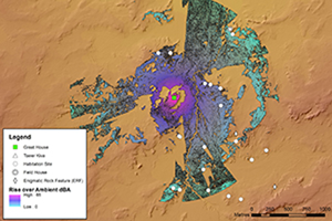
Kin Klizhin
Located along an ephemeral wash south-west of Chaco Culture National Historical Park, Kin Klizhin (LA 4975) is an ‘ancestral’ community consisting of a great house with a tower kiva (Figure 3), 23 habitation sites, irrigation features and three ERFs (Marshall et al. Reference Marshall, Stein, Loose and Novotny1979: 69–72; Powers et al. Reference Powers, Gillespie and Lekson1983; Powers & Van Dyke Reference Powers and Dyke2015). The Kin Klizhin community was populated during the late Pueblo I through early Pueblo III periods(AD 875–1150); we focus here on the late Pueblo II/early Pueblo III occupation. A trumpet blast from the great house would have been audible at the majority (16 of 23, 69.6%) of the habitation sites; a fieldhouse was also located within range (Figure 4). Statistical tests indicate this was highly unlikely due to chance alone (p ≤ 0.001; Table S1). The ERFs associated with Kin Klizhin show a tendency to be located away from the audibility zone; 2 of 3 (66.7%) were thus positioned. Unlike the habitation sites, statistical analyses show the relationship between ERFs and audibility may have been due to chance alone (p = 0.462; Table S1).

Figure 3. Kin Klizhin great house with tower kiva (LA 4935) (photograph by Van Dyke).

Figure 4. Modelled audible reach of a conch-shell blast from Kin Klizhin great house (figure by authors).
Morris 40
Located on Ute Mountain Ute Tribal Lands west of the La Plata River, Morris 40 is an ‘ancestral’ community situated on either side of a seasonal tributary of the San Juan River (Marshall et al. Reference Marshall, Doyel, Breternitz, Breternitz, Doyel and Marshall1982; Throgmorton Reference Throgmorton2019) (Figure 5). Morris 40 consists of a two-storey masonry great house (LA 1988), two great kivas, a road segment, a tower and over 40 habitations. The community was inhabited between AD 750 and 1300; here, our analysis focuses on the late Pueblo II occupation. Most (27) of the post-1050 habitations were located in areas that lie within the range of audibility from the great house. Nonetheless, a conch-shell trumpet blast would have been inaudible at about 30 per cent (n = 13) of the habitations in the community (Figure 6). The modelling point for six of these habitations was located only a few metres away from pixels that were passively or actively audible. With slight adjustments to the modelling location (within the area occupied by the habitation structure) these habitations would likely have been able to hear the conch-shell blast. The remaining seven habitations are 550–1050m away from the great house in low density areas of the community. In these cases, sound emanating from the great house is blocked by topography surrounding the habitation. All but one of these habitations is south of the great house. Ancient Pueblo houses are preferentially located on slopes with southern and south-eastern aspects, increasing the likelihood that topography would affect the audibility of sound coming from the great house. Three of the habitations are located along a Chaco-era road segment, which likely influenced site location.

Figure 5. Overview of the Morris 40 community, looking west-northwest. The great house is at the foot of the sandstone ridge left of the arroyo (photograph by Throgmorton).

Figure 6. Modelled audible reach of a conch-shell blast from Morris 40 great house (LA 1988) (figure by authors).
Padilla Wash
Padilla Wash is an ‘ancestral’ community located near the western boundary of Chaco Culture National Historical Park within shale badland outcrops (Throgmorton Reference Throgmorton2019). The community consists of an AD 1000s great house (LA 40352), an earlier proto-great house, a great kiva, road segments, constructed mounds and more than 25 domestic habitations dating from AD 750 to 1275. People continued to occupy eight habitations after the construction of the Chaco-style great house around AD 1020. A conch-shell trumpet blast was inaudible at half of the eight post-1020 habitations (Figure 7). All four of these are located on the southern or south-eastern slopes of low ridges, a preferred location for Ancient Pueblo habitations and one where topography is likely to affect the audibility of sounds emanating from the north. Because people constructed most habitations prior to erecting the Chaco-style great house, factors other than audibility may have influenced the location of habitation structures. However, Fisher's exact test returned a p-value of 0.009 even when half of the habitations were located outside of the zone of audibility.

Figure 7. Modelled audible reach of a conch-shell blast from Padilla Wash great house (LA 40352) (figure by authors).
Pierre's
Pierre's is a ‘scion’ community situated on the first major topographic break in the landscape north from Chaco Canyon, 19km north of Chaco Culture National Historical Park. The late Pueblo II/early Pueblo III period community articulates with the Great North Road, which extends due north from Chaco Canyon (Powers et al. Reference Powers, Gillespie and Lekson1983: 94–122; Harper et al. Reference Harper, Swift, Brandi and Winter1988). Pierre's community includes two great houses (House A and House B), an ERF atop a sandstone pinnacle (El Faro) and several other unusual structures. Researchers have documented 26 associated sites including nine habitations; additional ERFs are located on mesa tops along the topographic boundary of the community. Elevated sites at Pierre's are intervisible with Chaco Canyon.
Pierre's modelling illustrates that six out of nine (66.7%) habitations were located in the audibility zone of a conch-shell blast from Great House A (Figure 8) and seven out of nine (77.8%) in the audibility zone of a similar sound from El Faro (Figure 9). Modelling points for the structures outside of the audibility zone were located more than 10m away from pixels indicating audibility, so it seems unlikely that individuals would hear a trumpet blast at these locations. Pierre's community contained eight ERFs, of which seven (87.5%) were located in the audible zone, sometimes in isolated patches of audibility. In all scenarios, statistical tests indicate the positioning of these sites was extremely unlikely to be related to chance alone (p = 0.001, ≤ 0.001, and ≤ 0.001, respectively; Table S1).

Figure 8. Modelled audible reach of a conch-shell blast from Pierre's Great House A (LA 16509) (figure by authors).

Figure 9. Modelled audible reach of a conch-shell blast from Pierre's El Faro (LA 16514) (figure by authors).
Discussion
Statistical analyses conducted on the soundscape modelling results illustrate some interesting patterns. Broadly speaking, most habitations within late Pueblo II/early Pueblo III Chacoan communities are within the range of audibility for a conch-shell trumpet blown from atop a great house or prominence within a community (such as El Faro at Pierre's). Choosing results from models where audibility zones included as many habitation sites as possible, and assuming sites located within 10m from an audibility zone were able to hear shell-trumpet blasts, at best a chi-square test for association indicated that there was no statistically significant difference (χ2 = 2.4956, p = 0.645; Table S2) between the five communities when considering the location of habitation sites. But even under more stringent parameters, the result remains consistent (χ2 = 1.1267, p = 0.890; Table S3). All five communities therefore exhibit the same preference to place habitation sites within audibility zones. A series of Fisher's exact tests indicates that this pattern is not random. Conversely, ERFs may not show such selectivity in placement. Sample sizes for ERFs are, however, small and resulted in test violations. Additional modelling and analysis will need to be conducted to determine if this pattern holds.
A pattern emerges when we contrast the three ‘ancestral’ communities (Kin Klizhin, Padilla Wash and Morris 40) with the two ‘scion’ communities (Bis sa'ani and Pierre's). In both the best-case and worst-case scenarios, a slightly higher percentage of habitations are located within audibility zones in ‘scion’ communities (Table S4). This may reflect increasing formality in settlement locations in the later (post-1100) Chacoan world—a phenomenon noted by Van Dyke and colleagues (Reference Van Dyke, Bocinsky, Windes and Robinson2016) in visibility studies and by Throgmorton (Reference Throgmorton2019) in community landscape design. However, habitations at both ‘scion’ and pre-existing communities are equally statistically likely to be located within zones of audibility (see Table S5). The organisation of habitations within communities with pre-Chacoan antecedents may reflect other concerns, such as the strong preference for south-east-facing houses or consideration of the location of earlier buildings, yet the consistently high proportions of habitations within the range of audibility suggests that auditory experience may have been a component in the design of Late Pueblo II Chacoan landscapes. The placement of ERFs may or may not contravene this trend. ERFs in the ‘scion’ community of Pierre's seem to be placed intentionally, while Kin Klizhin ERFs are more randomly placed throughout the landscape (Table S6). It is not known whether these patterns exist for sites outside the late Pueblo II/early Pueblo III time period (AD 1020–1150).
A comparison of shell-trumpet audibility to the viewshed from the Padilla Wash great house demonstrates that there is considerable overlap in sensory range (Figure 10, purple shading), but visibility extends further than audibility. Earlier work shows intervisibility was important for making connections between Chacoan communities (Van Dyke et al. Reference Van Dyke, Bocinsky, Windes and Robinson2016). By contrast, the acoustic reach of a conch-shell trumpet could have been one way of ensuring the internal cohesion of Chacoan communities. If leaders atop great houses needed to quickly communicate with all community residents, a conch-shell blast would have been a more effective method than relying on community residents to look in the right direction at the right time to see, for example, smoke/mirror signals. It is possible that habitation site distributions fall within the conch-shell blast area because community members did not wish to live, or were not permitted to live, where they could not be reached. That said, we need to consider the sites that fall outside the blast range; other factors, such as agricultural productivity, would also have influenced the choice of habitation site location.

Figure 10. Comparison of viewshed and soundscape from Padilla Wash great house (LA 40352) (figure by authors).
The work presented here is a brief summary of studies under development. We plan to study audibility zones (passively audible; actively audible; likely passively audible; likely actively audible and inaudible) in more detail and continue our inquiries at additional sites. Morris 40, with its long timespan (AD 750–1300), is an ideal community for examining changes in auditory experiences over time. We also need to model the spread of a conch-shell blast from a great house where community sites are not yet recorded and then survey the community to determine how accurately our model predicts community boundaries; this is not yet feasible for a host of reasons, including the need for permits and lack of lidar data.
Conclusions
Sensory experiences in archaeological landscapes can be studied by archaeologists. Our study of soundscapes in Chacoan great-house communities allows a tantalising glimpse into community cohesion. Our research suggests that, like the reach of the sound of a church bell in medieval times, the sound of a conch-shell trumpet may have been one element binding Chacoan communities together.
Soundsheds provide a new and intriguing means for managing and protecting the greater Chacoan landscape: areas of heightened concern for cultural and historic resource protection could be delineated by mapping the spread of sound from the locations of great houses. Federal and state land-management agencies would be able to incorporate this information into decision making, permitting activities and environmental impact analyses. We offer this tool as one of many within a management toolbox. The presence of these areas should be considered in concert with the presence of Tribal treaty rights, endangered species, unique geologic resources, and traditional cultural landscapes and properties, among others.
If we are to understand a Chacoan sense of place, archaeologists must devise creative methods for studying sensory experiences, including soundscapes. Our modelling offers a useful way forward. In an era of rapidly advancing economic development, it is imperative for archaeologists to help government personnel and legislators develop good management strategies for the fragile and understudied aspects of the ancient sensory world. Predictive models acoustically locating community boundaries can help landowners and agencies figure out how to evaluate, study and mitigate potentially damaging effects from development.
Acknowledgements
Geospatial data were collected from Kin Klizhin under National Park Service Permit CHCU-10-01, from Padilla Wash under NPS Permit 17-CHCU-03 and from Morris 40 under Ute Mountain Ute Tribal Permit #17-05. Updated locational information from Pierre's community was collected under the Bureau of Land Management Cultural Resource Use Permit #306-2920-20-D. Lidar data were provided by Bureau of Land Management Farmington Field Office. Open Access to this article is provided courtesy of Binghamton University Libraries.
Funding statement
Fieldwork at Padilla Wash and Morris 40 was funded by the National Science Foundation (DDRIG #1741893) and grants from the New Mexico Archaeological Council and PaleoWest Foundation.
Supplementary material
To view supplementary material for this article, please visit https://doi.org/10.15184/aqy.2024.54.


 Open access